6683 Halsey Street
 More Photos

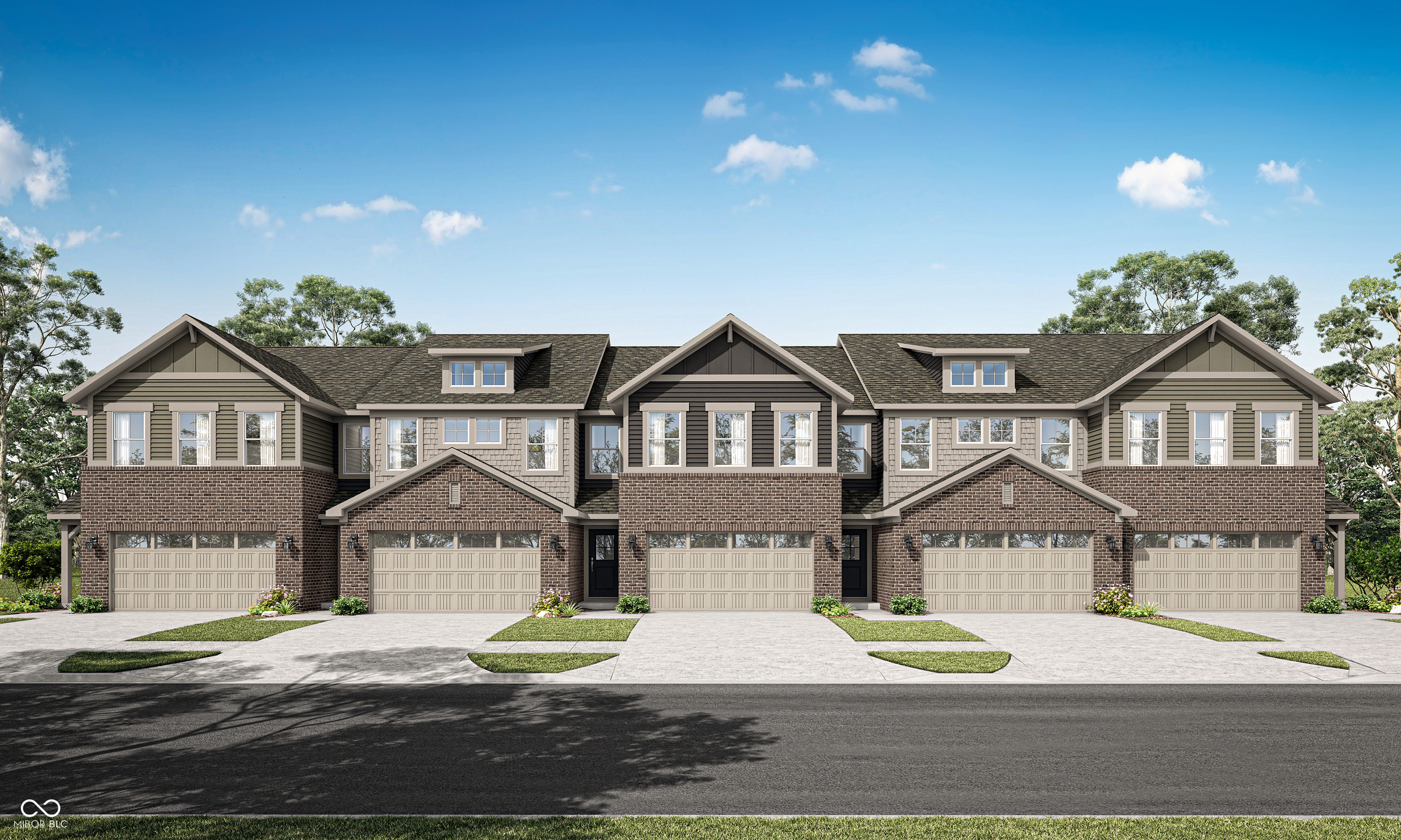
6683 Halsey StreetZionsville, IN 46077


Pending
$299,995
Asking Price
3
Bd
3
Ba
1,727
Sqft
2,320
Sqft Lot

6683 Halsey Street Zionsville, IN 46077


TownhouseProperty Type
18 daysTime pending
$196Price per sqft
2 carsGarage
2025Year Built
$585Paid Quarterly
2-Story Townhomes is a collection offering new two-story townhomes for sale at the Ellis Acres masterplan, coming soon to charming Zionsville, IN. Residents will have access to ample outdoor recreation at nearby Lions Club Community Park and Eagle Creek Park, where nature lovers can kayak, fish, hike and play a round of golf. Zionsville has a small-town vibe with unique eateries and experiences, and premier dining, shopping and entertainment are available in Downtown Zionsville. This two-story townhome-style condo makes smart use of the available space. The open living area is on the first floor and includes a kitchen, family room and dining area with a covered patio attached. Upstairs are three bedrooms, including the owner's suite, as well as a versatile loft and laundry room. *Photos/Tour of model may show features not selected in home.
Walking paths, and trees in Trailside (Whitestown)
Whitestown
Metro in Indiana

Approximate location on a geospatial gridNorthern Suburbs
Icon
Suburban
Living
Icon
Parks &
Playgrounds
Icon
New Construction
Buyer Blueprint

The plan that gets you home.

Learn More

Year Built

2025

City

Zionsville

Type

Townhouse

Neighborhood

Whitestown

County

Boone

Lot Size

0.05 ac / 2,320 sqft
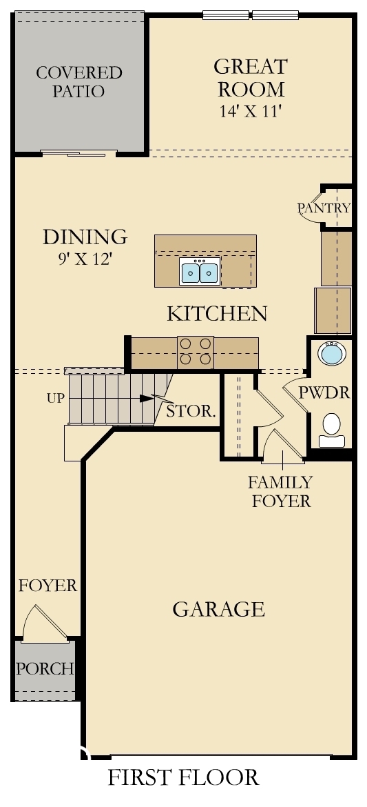
Bedrooms

3

Full Bathrooms

2

Half Bathrooms

1

Garage Capacity

2

Living Area Total

1,727 sqft

Price per sqft

$195.71

Living Area Main & Upper

1,727 sqft

Connect with a Dwellane Agent

Like what you see? Our trusted agents are ready to help you take the next step.

Listing Agent

Erin Hundley
317-430-0866

Buyer Agent

Priscilla Russell
317-590-7342

Listing Provider

Compass Indiana, LLC

MLS #

22039177

Source

MIBOR as distributed by MLS GRID

Last Modified

Mon Jun 30 2025

Pending on

Jun 29 2025

Listed on

Fri May 16 2025


Property History

Loading...

Whitestown

Approximate location on a geospatial gridNorthern Suburbs
Whitestown media

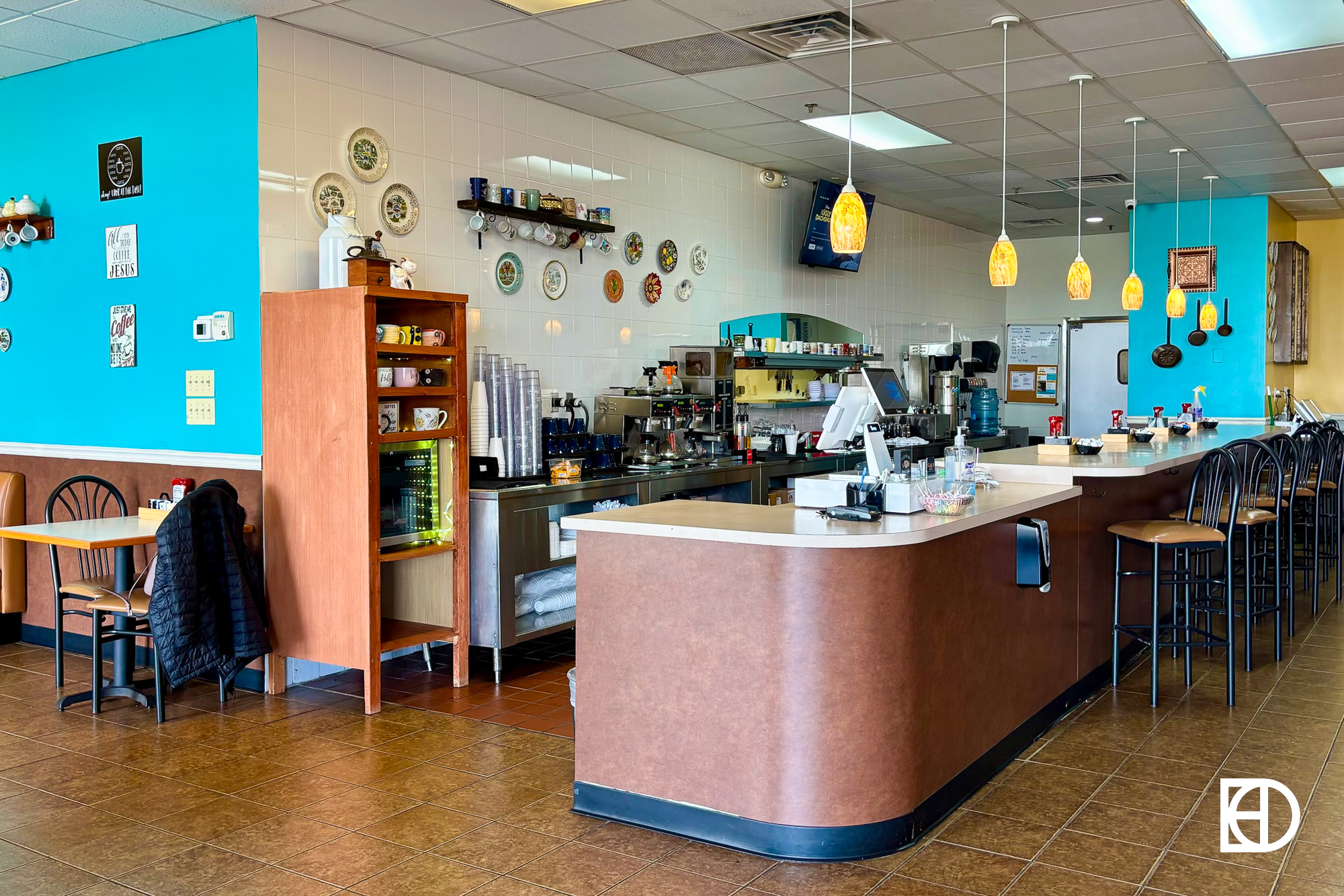
Whitestown is a thriving and rapidly growing community that blends small-town charm with modern conveniences. Just 22 miles northwest of Indianapolis, Whitestown gives residents easy access to the city's amenities while maintaining a friendly, close-knit vibe that feels worlds away from the hustle and bustle. The dining scene here is a highlight, with local favorites like Moontown Brewing Company, housed in a repurposed high school gym, offering craft beer and live music. L.A. Café is another gem, known for its cozy ambiance and delicious shrimp cocktail. For sweet treats, Fundae’s Ice Cream & Sweets is a go-to spot for families. The Shoppes at Whitestown and Whitestown Corner Market provide convenient retail options for residents, with everything from unique boutiques to everyday essentials.

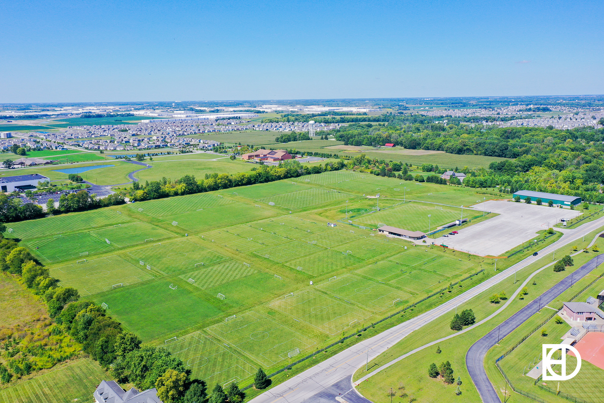
Outdoor enthusiasts will love Whitestown’s focus on recreation. The town boasts over 12 miles of trails and 50 acres of parks, including playgrounds, splash pads, and sports facilities. The Big 4 Trail, a favorite among locals, provides a scenic route for walking or biking and connects Whitestown to neighboring Zionsville. For a unique experience, Hickory Hall Polo Club hosts family-friendly polo matches during the summer, complete with halftime candy drops for kids. Nearby Eagle Creek Park, one of the largest urban parks in the country, offers endless opportunities for hiking, fishing, and boating.

Rich in history, Whitestown was named after Albert S. White, a U.S. senator, railroad president, and abolitionist. The Big Four Trail, a local favorite, preserves this history by transforming an old rail line—once traveled by President Lincoln’s trains—into a beautiful walking and biking path. Over the last decade, Whitestown has been Indiana’s fastest-growing community, now home to over 10,000 residents. Community spirit is strong in Whitestown, with events like the Independence Day celebration, Brewfest, and seasonal farmers markets bringing residents together. Recognized as one of the top 25 most popular small towns in the U.S., Whitestown is the kind of place that makes you feel right at home, whether you're starting fresh, raising a family, or enjoying a new chapter in life.

Neighborhood Features

Icon
Suburban
Living
Icon
Parks &
Playgrounds
Icon
New Construction
Icon
Family
Fun

Nearby Neighborhoods

Aerial view of Monument Circle in downtown Indianapolis, showing the Soldiers and Sailors Monument surrounded by tall buildings and city streets.
Aerial photo of Victory Field
Aerial photo of Lucas Oil Stadium
Metro in Indiana

Approximate location on a geospatial gridCentral Indy
Icon
Arts &
Culture
Icon
Family
Fun
Icon
Parks &
Playgrounds
Exterior photo of Downtown Zionsville, showing Abraham Lincoln mural on the side of a brick building
Photo of Meeting House front entrance in Stonegate neighborhood in Zionsville, Indiana.
Photo of playground in The Willows neighborhood in Zionsville.
Exterior photo of Starkey Park, showing river, bridge, and trees
Aerial photo of Starkey Park, showing river, bridge, and woods
Aerial photo of Noah Grant's in Zionsville
Photo of entrance to Lions Park in Zionsville
Exterior photo of Brick Street Inn, showing patio and seating, tables with umbrellas, and fencing
Exterior photo of Lincoln Park, showing gazebo and landscaping
Metro in Indiana

Approximate location on a geospatial gridNorthern Suburbs
Icon
Arts &
Culture
Icon
Quintessential
Main St.
Icon
Stacked
with Storefronts
A brick neighborhood entry sign with a faintly engraved stone displaying the words Eagles Nest, surrounded by houses and shrubbery.
A suburban neighborhood with single-family homes, green lawns, trees, and a clear blue sky on a sunny day.
A small brick pavilion with a gabled roof, white trim, and covered walkway, surrounded by leafless trees and landscaped mulch beds under a partly cloudy sky.
An outdoor swimming pool with partial water, surrounded by a concrete deck, metal fence, and nearby pavilion under a clear sky.
Outdoor basketball court with two hoops, surrounded by grass, benches, and residential houses under a partly cloudy sky.
Empty outdoor tennis court with a net, surrounded by a chain-link fence, grass field, and houses in the background under a partly cloudy sky.
A playground structure with green slides, ladders, and climbing features stands on wood chips with grass, trees, and houses in the background under a blue sky.
A playground with climbing structures and slides is surrounded by trees and a circular path, with a pavilion building in the background under a blue sky.
Large rock on grassy field near a pond with suburban houses in the background under a blue sky.
A suburban residential street with houses on both sides, a roundabout with a brick sign in the center, and a partly cloudy blue sky above.

Approximate location on a geospatial gridNorthern Suburbs
Icon
Neighborhood
Pool
Icon
Clubhouse
Icon
Parks &
Playgrounds
Signage, and landscaping in Westwood Landing (Whitestown)-1
Roads, and homes in Westwood Landing (Whitestown)
Shelter, and landscaping in Westwood Landing (Whitestown)
Seating, and landscaping in Westwood Landing (Whitestown)
Pond, and landscaping in Westwood Landing (Whitestown)
Roads, and homes in Westwood Landing (Whitestown)
Pond, and landscaping in Westwood Landing (Whitestown)
Signage in Westwood Landing (Whitestown)

Approximate location on a geospatial gridNorthern Suburbs
Icon
Parks &
Playgrounds
Icon
Suburban
Living
Icon
Family
Fun
Greenspace, and signage in Cardinal Pointe (Whitestown)
Walking paths, and trees in Cardinal Pointe (Whitestown)
Roads, and homes in Cardinal Pointe (Whitestown)
Pond, and landscaping in Cardinal Pointe (Whitestown)
Greenspace, and homes in Cardinal Pointe (Whitestown)
Roads, and homes in Cardinal Pointe (Whitestown)
Greenspace, and trees in Cardinal Pointe (Whitestown)
Signage, and landscaping in Cardinal Pointe (Whitestown)

Approximate location on a geospatial gridNorthern Suburbs
Icon
Golf
Icon
Easy on
the Commute
Icon
Lifestyle
& Recreation
Landscaping, and homes in Townhomes of Anson (Whitestown)
Roads, and homes in Townhomes of Anson (Whitestown)
Walking paths, and homes in Townhomes of Anson (Whitestown)
Roads, and homes in Townhomes of Anson (Whitestown)
Landscaping, and homes in Townhomes of Anson (Whitestown)
Walking paths, and homes in Townhomes of Anson (Whitestown)
Signage, and walking paths in Big Four Trail (Whitestown)
Walking paths, and trees in Trailside (Whitestown)

Approximate location on a geospatial gridNorthern Suburbs
Icon
Suburban
Living
Icon
Parks &
Playgrounds
Icon
Family
Fun
Signage, and landscaping in Clark Neighborhoods at Anson (Whitestown)
Homes, and roads in Clark Neighborhoods at Anson (Whitestown)
Pond, and walking paths in Clark Neighborhoods at Anson (Whitestown)
Playground in Clark Neighborhoods at Anson (Whitestown)
Playground, and landscaping in Clark Neighborhoods at Anson (Whitestown)
Picnic table, and landscaping in Clark Neighborhoods at Anson (Whitestown)
Signage, and walking paths in Clark Neighborhoods at Anson (Whitestown)
Signage, and landscaping in Clark Neighborhoods at Anson (Whitestown)
Landscaping, and pond in Clark Neighborhoods at Anson (Whitestown)
Walking paths, and homes in Clark Neighborhoods at Anson (Whitestown)
Homes, and roads in Clark Neighborhoods at Anson (Whitestown)
Signage, and roads in Clark Neighborhoods at Anson (Whitestown).jpg

Approximate location on a geospatial gridNorthern Suburbs
Icon
Neighborhood
Pool
Icon
Sports
& Activities
Icon
Parks &
Playgrounds
Photo of entrance column sign at Stonegate neighborhood in Zionsville, Indiana.
Exterior photo of Stonegate, showing fountain and landscaping
Exterior photo of Stonegate, showing roads, homes, trees, and landscaping
Exterior photo of Stonegate, showing clubhouse and landscaping
Exterior photo of Stonegate, showing roads, homes, trees, and landscaping
Exterior photo of Stonegate, showing roads, buildings, a small park, and landscaping
Exterior photo of Stonegate, showing buildings, roads, and landscaping
Exterior photo of Stonegate, showing roads, homes, trees, and landscaping
Exterior photo of Stonegate, showing pool and landscaping
Aerial photo of Starkey Park, showing river, bridge, and woods
Aerial photo of Lion's Park, showing baseball field and woods
Exterior photo of Lincoln Park, showing walking paths, trees, and green space
Neighborhood in West Zionsville

Approximate location on a geospatial gridNorthern Suburbs
Icon
Established
Icon
Family
Fun
Icon
Spacious
Lots
Signage, and landscaping in Clark Meadows at Anson (Whitestown)
Roads, and homes in Clark Meadows at Anson (Whitestown)
Playground in Clark Meadows at Anson (Whitestown)
Clubhouse in Clark Meadows at Anson (Whitestown)
Pool, and clubhouse in Clark Meadows at Anson (Whitestown)
Basketball court, and basketball court in Clark Meadows at Anson (Whitestown)
Signage, and landscaping in The Manors at Clark Meadows (Whitestown)
Roads, and homes in The Manors at Clark Meadows (Whitestown)
Roads, and trees in The Manors at Clark Meadows (Whitestown)
Signage, and picnic table in Big Four Trail (Whitestown)
Walking paths, and trees in Trailside (Whitestown)
Exterior photo of Main Street Park in Whitestown, showing playground equipment and shelter
Neighborhood in Whitestown

Approximate location on a geospatial gridNorthern Suburbs
Icon
Sports
& Activities
Icon
Neighborhood
Pool
Icon
Parks &
Playgrounds
Signage, and landscaping in Edmonds Creek (Whitestown)
Roads, and homes in Edmonds Creek (Whitestown)
Signage, and landscaping in Edmonds Creek (Whitestown)
Signage, and walking paths in Big Four Trail (Whitestown)
Exterior photo of Big Four Trail, showing walking path, trees, and landscaping
Signage, and picnic table in Big Four Trail (Whitestown)
Walking paths, and trees in Trailside (Whitestown)
Exterior photo of Main Street Park in Whitestown, showing playground equipment and shelter

Approximate location on a geospatial gridNorthern Suburbs
Icon
Newer Homes
Icon
Parks &
Playgrounds
Icon
Suburban
Living
Aerial photo of Mulberry Fields sports fields, showing green space and landscaping
Aerial photo of Starkey Park, showing river, bridge, and woods
Exterior photo of Lincoln Park, showing gazebo and landscaping
Exterior photo of Heritage Trail Park, showing playground, shelter, and landscaping
Aerial photo of Mulberry Fields Park, showing parking lot, woods, buildings, and sports fields

Approximate location on a geospatial gridNorthern Suburbs
Icon
Easy on
the Commute
Icon
Family
Fun
Icon
Newer Homes
BESbswy