
Asa Bales Park

Icon for ParkPark
More Photos

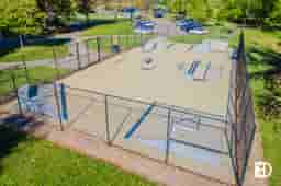
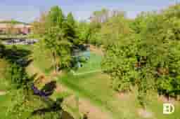
In the heart of Westfield, Asa Bales is a 13 acre park that can be accessed from Hoover Street with parking available at 200 Camilla Court. Along with the Thompson Canal that flows through Asa Bales, the park also features a beautiful walking path that winds through the park and connects to Downtown Westfield and Grand Junction Trail. There is a new playground at Asa Bales Park. The playground was designed with the help of Westfield Middle School students.

Address205 W. Hoover Rd. Westfield, IN 46074
Dwellane Agents

Like what you see in
Westfield?

Connect with a trusted Dwellane Agent to
learn more and find your perfect home.

Westfield

Approximate location on a geospatial gridNorthern Suburbs
Westfield media

Westfield, Indiana combines historic character with modern development, offering residents a balanced lifestyle just north of Indianapolis. The city has experienced rapid growth since becoming an official city in 2008, all while preserving its original charm. Downtown Westfield features historic architecture alongside new public amenities, including the recently completed Westfield Washington Public Library and Grand Junction Plaza — a community gathering space that hosts seasonal events like summer farmers markets and winter ice skating. Locally owned spots like The Italian House on Park and Rivet add to the dining and social options within walking distance of downtown.

Westfield is also known for its commitment to parks, trails, and recreation. The Monon Trail and Midland Trace Trail provide miles of walking and biking paths, connecting neighborhoods to downtown and neighboring communities. Grand Park Sports Campus, one of the largest youth sports facilities in the U.S., attracts visitors year-round for tournaments, training, and events. Beyond the sports fields, Westfield’s 15+ parks and growing greenways offer plenty of room for outdoor activity. Whether you’re exploring the trails, enjoying a concert at Grand Junction Plaza, or grabbing a coffee downtown, Westfield delivers a strong sense of connection through its local amenities, walkability, and thoughtful growth.

Neighborhood Features

Icon
Family
Fun
Icon
Newer Homes
Icon
Parks &
Playgrounds
Icon
Sports
& Activities

Nearby Neighborhoods

Signage, and landscaping in Harvest Park
Neighborhood

Approximate location on a geospatial gridNorthern Suburbs
Icon
Parks &
Playgrounds
Icon
Sports
& Activities
Icon
Lush Landscape
Signage, and landscaping in Heritage Meadows (Fishers)
Neighborhood

Approximate location on a geospatial gridNorthern Suburbs
Icon
Parks &
Playgrounds
Icon
Lush Landscape
Icon
Established
Signage, and landscaping in Clark Meadows at Anson (Whitestown)
Neighborhood

Approximate location on a geospatial gridNorthern Suburbs
Icon
Sports
& Activities
Icon
Neighborhood
Pool
Icon
Parks &
Playgrounds
Clubhouse, signage, and landscaping in Carmelaire-Carmeltown (Central Carmel)
Neighborhood

Approximate location on a geospatial gridNorthern Suburbs
Signage, and landscaping in Meadow Brook Village (Fishers)

Approximate location on a geospatial gridNorthern Suburbs
Signage, and landscaping in Cumberland Place (Fishers)
Neighborhood

Approximate location on a geospatial gridNorthern Suburbs
Exterior photo of Harrison Lakes, showing signage on small brick wall and landscaping
Neighborhood

Approximate location on a geospatial gridNorthern Suburbs
Icon
Parks &
Playgrounds
Icon
Family
Fun
Icon
Lush Landscape
Signage, and landscaping in Edmonds Creek (Whitestown)

Approximate location on a geospatial gridNorthern Suburbs
Icon
Newer Homes
Icon
Parks &
Playgrounds
Icon
Suburban
Living
Greenspace, trees, and landscaping in Geist Bay Estates (Fishers)
Neighborhood

Approximate location on a geospatial gridNorthern Suburbs
Roads, trees, and homes in Harrison Pointe (Fishers)
Neighborhood

Approximate location on a geospatial gridNorthern Suburbs
Homes, roads, and trees in Country Fields at Fishers (Fishers)

Approximate location on a geospatial gridNorthern Suburbs
BESbswy